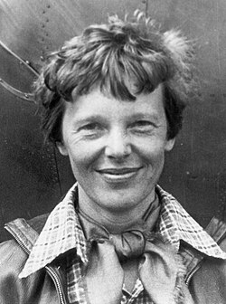
Amelia Earhart was an early pioneer in American aviation having become the first female passenger to cross the Atlantic Ocean, and later the first female to fly solo across the Atlantic. She was an early promoter of commercial air travel writing best-selling books about her flying activities and experiences. In May, 1937, she attempted to become the first female pilot to fly completely around the earth, but she disappeared along with her navigator on July 2, while attempting to cross the Pacific Ocean. Extensive searching did not produce a trace of where she wound up or what happened. As we drill down to what we know about the excursion was it doomed to failure?
The First Attempt to Circumnavigate the Earth Failed: With a crew of three, Earhardt took off from Oakland California to circle the earth using an equatorial route traveling east to west. The crew included Fred Noonan, the navigator, Paul Mantz, technical advisor, and Harry Manning, radio operator. The group made it to Hawaii, but an accident occurred on the takeoff for the next leg to Howland Island in the Pacific. The plane, a Lockheed Electra 10E, incurred some damage and was sent back to the Lockheed Aircraft Company in Burbank, California for repairs. In the process of the repairs some navigational and safety equipment was removed to reduce weight. Further, Manning, the only skilled radio operator, quit the crew, and Mantz remained an advisor but did not continue with the second attempt. This left Earhardt and Noonan to handle everything, including radio direction finders and celestial navigation. On May 20, 1937, with the plane fully repaired, the duo flew to Miami to begin the first leg of the second attempt on June 1, 1937. Hoping to maximize good weather they reversed their itinerary traveling west to east through South America, across to Africa, through India and Burma on their way to Lae, New Guinea, their jumping off point to cross the Pacific. Their stop in Darwin, Australia, included some repairs to their radio direction finder and the removal of their two parachutes for weight purposes.
The Flight from Lae to Howland Island: On July 2, they took off for Howland Island, a small speck of land about 1.25 miles long and about 0.30 mile wide. They would fly over the pacific for 2,500 miles taking over twenty hours. To assist this difficult leg of the trip the U.S. Coast Guard sent the cutter Itasca to Howland Island’s waters to provide communications and homing signals, and to send up a column of smoke from their boilers to aid visualization. They flew all night with little concern until 6:14 am when they made a call to the Itasca to send a bearing using their directional finder. This was when a group of adverse happenings began to take place that caused the expedition to collapse.
The Plane Had Less Fuel Than Expected: The day before leaving Lae, the plane was loaded with about 1,100 gallons of gasoline that on paper appeared to be more than enough to reach Howland. However, owing to the tropical heat, the fuel condensed slightly overnight reducing the actual amount to 1,092. This still should have been enough for the flight, but in the circumstances, the extra fuel would have helped the plane to fly longer in its search for the island. It is not clear if Earhart was aware of the fuel situation.
A Heavy Cloud Layer Forced the Plane to Fly at a Lower Altitude: After flying for about five hours Earhart sent a radio message that that they would need to reduce their altitude from 10,000 feet to 3,000 feet owing to a heavy cloud cover. About two hours later she again reported her altitude this time at about 7,000 feet with a speed of about 170 miles per hour. They planned to rely on celestial navigation to help them find Howland Island and would need to fly above the cloud cover to do so. The lower altitudes reduced visibility considerably versus what they may have been able to see higher up on a clear day. If they were approaching on the west side of the island flying east, they would have had early morning sunlight in their vista further hampering visibility.
The Map Was Out of Date: The map Noonan was using was out of date and showed Howland Island to be as much as six miles to the east from where they expected it to be. The new, updated map was available, but they began the journey before they were able to get a copy of it. Six miles off would not be an insurmountable obstacle by itself if their visibility was from a high enough altitude and the weather clear in all directions.
Noonan’s Dead Reckoning Calculations Did Not Account for Local Wind or Compass Deviation: Noonan’s charts from previous legs of the journey were dropped off at Darwin apparently to remove clutter from their crowded cockpit. But they showed how his thinking worked and a clear error was discovered: He did not allow for compass deviation or the speed and direction of local wind. The concept was that flying over land, the pilot or navigator could identify and relate to objects, benchmarks, or small fires lit especially to mark a route. But flying in darkness over an ocean severely limited observation of passing landmarks, especially if no other land masses were in the area. It further precluded any chance for Noonan to estimate surface wind speed and/or direction by observing waves. As it was, the flight was subtly impacted by an easterly wind of four to eight miles per hour that could have pushed the plane as much as eighteen miles off course to the west of Howland without either person in the plane realizing it. Compass deviation between the magnetic North Pole and the true North Pole could also impact the plane’s direction, and even electronic or magnetic devices inside the plane could alter the correct reading. It was later estimated that their compass deviation was about four degrees, and for a flight of that distance it could have meant a difference of about six miles to the west. Add another six miles from the incorrect map and it becomes a twelve-mile deviation. Add another adjustment for the wind and they could have been nearly twenty miles off course without realizing it. Visual range to spot the island was about twenty miles from any direction except the west where the early morning sun hampered the view and reduced visibility to about fifteen miles.
The Timing of the Radio Signals Between Plane and Ship Was Different: Earhart was using Greenwich Civil Time (GCT), but the crew on the Itasca was using Hawaiian Standard Time minus one hour, a Naval time-zone designation system. The result was that the plane was on the hour at the same time the ship was on the half-hour. Earhart signaled in that she would transmit messages fifteen minutes before and after the hour, and expect their message replies on the hour and on the half hour. Earhart had the plane’s transmitter switched on only at the times that she stipulated. The ship’s crew co-operated with their transmissions, but kept their equipment running so as to pick up anything else that could be important. This timing anomaly served to inhibit any voice transmission from reaching the plane until just before they ran out of fuel.
The State-of-the-Art Radio Direction Finder Was Brand New and Not Understood: With Henry Manning opted out of the journey, the remaining duo lacked his experience with radio communications and direction finding. Earhart had only a brief overview on how to use the new direction finder, and did not take the time to try it out. Unaware that low frequencies were crucial to radio direction finding, she removed the trailing wire that would enable the plane’s unit to receive them. If the plane’s RDF could not receive any signals, it further meant that they were unable to send any. At 6:14 am Earhart called in that they were within 200 miles and needed the ship to use its direction finder to provide her with a bearing. To supplement the request, she began whistling into her microphone in an effort to create a continuous signal. The ship’s operators realized at this point that their own RDF system could not tune into the aircraft’s voice signals as the frequency was too high. This request was repeated at 6:45 am with the plane about 100 miles away. Over an hour later at 7:58 am Earhart again messaged that they could not hear the ship and to send voice signals for an RDF bearing. The ship could not send voice signals at the frequency she requested, but instead sent Morse code as they knew that should work. She acknowledged receiving the Morse code, but said they were unable to pick up the direction. At this point the ship estimated that the plane had less than half an hour of fuel remaining. In the last voice transmission from the plane, Earhart said that they were flying north-to-south, at 157 to 337 degrees on a line that they thought would pass directly through Howland Island. However, this azimuth is actually south-southeast to north-northwest meaning that they were flying slightly to the west. Considering that between the map, the compass deviation, and the wind direction, they went down flying away from the island as they were most likely already west of it.
Conclusions: In the state of the art of those times, reaching a small island standing alone miles away from any other land mass would be a tricky problem in the leastways. Navigation, radio communications, and visibility all would be crucial to find a tiny spot in the earth’s largest ocean from the air. The official record has them being “lost at sea.” Retired U.S. Navy Captain Laurance Safford, did an analysis of the flight in the 1970’s focusing mainly on the ship’s transmissions logs. His conclusion was that the flight suffered from a combination of bad planning and worse execution. The U.S. government did a major search beginning with Itasca about an hour after the last transmission. The Itasca searched the area north and west of Howland, and the Navy joined in the search over the next three days. The official search lasted for about two weeks turning up nothing. There were several subsequent private searches, again to no avail. Theories of how they disappeared have also arisen, but have largely been debunked.
Sources: National Geographic History & Culture, Did These Small Mistakes Doom Amelia Earhart? By Rachel Hartigan, March 3, 2026.
Wikipedia, Amelia Earhart.